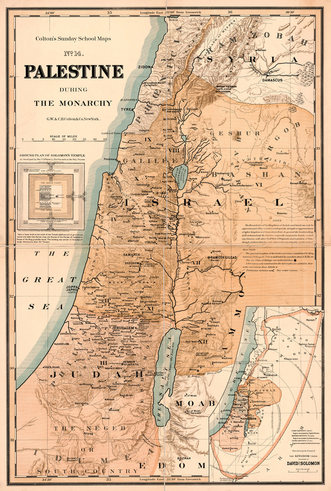


1895 Map Palestine During Monarchy Israel Christianity Wall Art Poster Print
1895 Map of Palestine During the Monarchy. Detailed Specifications This is a reproduction of the original map This Map Comes in Sizes: 11"x16", 16"x24" and 23"x34" Remember, the smaller the map size, the smaller the print, that means it is harder to read the text! We Have More Israel and Palestine Maps in Our Store We Have More Religious Maps in Our StoreAll Our Maps and Posters Are Made in the USA Shows ancient kingdoms and nations, 12 provinces stablished by King Soloman, 6 cities of refuge, small towns, and villages. Includes inset of "The Kingdom under the reigns of David & Soloman" and Grand plan of Soloman's temple. This map comes with a white border around the image --------------------------- -How are the prints shipped? They are rolled and placed into a rigid tube or box. -Is this available in a larger/smaller size. Yes. For smaller or larger sizes, email us.
Specifications
| Return Shipping Will Be Paid By | Seller |
| All Returns Accepted | Returns Accepted |
| Item Must Be Returned Within | 30 Days |
| Artist | Unknown |
| Origin | United States |
| Date Of Creation | 1800-1899 |
| MPN | Does Not apply |
| Item Length | 3 variations |
| Department | Teens |
| Unit Type | Unit |
| Item Height | 3 variations |
| Style | Vintage/Retro |
| Features | Unframed |
| Production Style | Printed |
| Room | Any Room |
| Item Width | 3 variations |
| Character | Map |
| Color | Multicolor |
| Material | Paper |
| Orientation | Vertical |
| Subject | Maps |
| Brand | Unbranded |
| Type | Poster |
| Original/Reproduction | Reproduction |
| Theme | Maps |
| Country/Region Of Manufacture | United States |
| Character Family | Maps |
1895 Map of Palestine During the Monarchy. Detailed Specifications This is a reproduction of the original map This Map Comes in Sizes: 11"x16", 16"x24" and 23"x34" Remember, the smaller the map size, the smaller the print, that means it is harder to read the text! We Have More Israel and Palestine Maps in Our Store We Have More Religious Maps in Our StoreAll Our Maps and Posters Are Made in the USA Shows ancient kingdoms and nations, 12 provinces stablished by King Soloman, 6 cities of refuge, small towns, and villages. Includes inset of "The Kingdom under the reigns of David & Soloman" and Grand plan of Soloman's temple. This map comes with a white border around the image --------------------------- -How are the prints shipped? They are rolled and placed into a rigid tube or box. -Is this available in a larger/smaller size. Yes. For smaller or larger sizes, email us.
Related Items