


Virginia Civil War Battlefield 1912 Map Military Battles Wall Art Poster Print
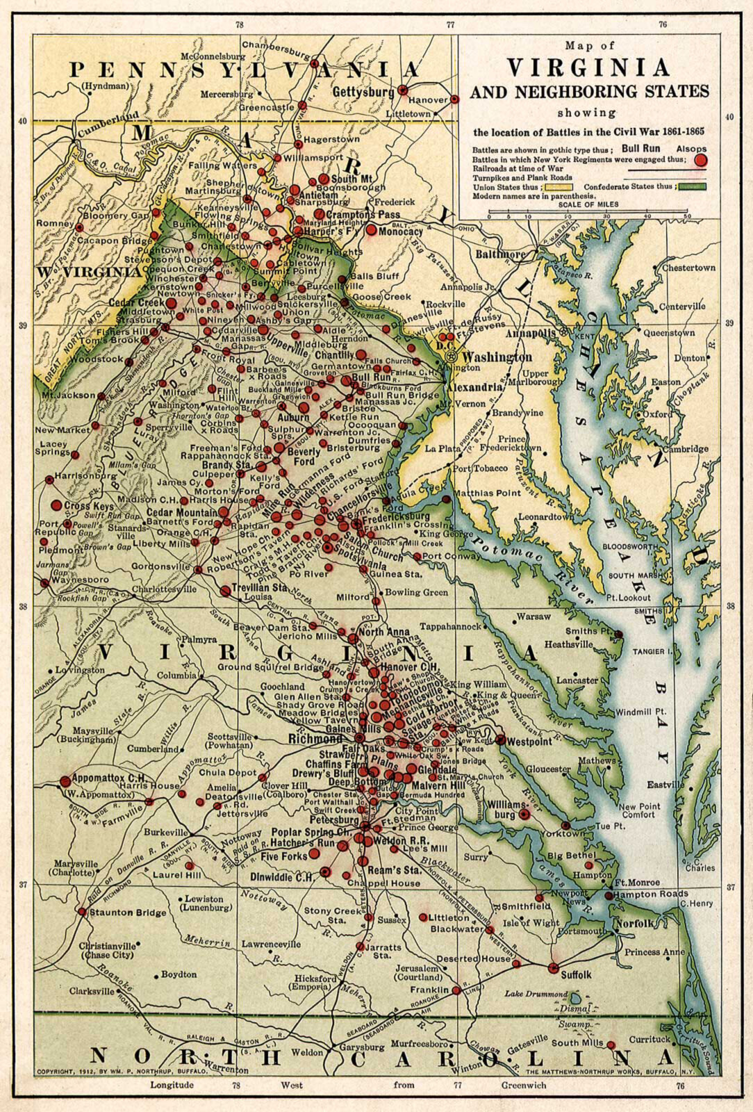
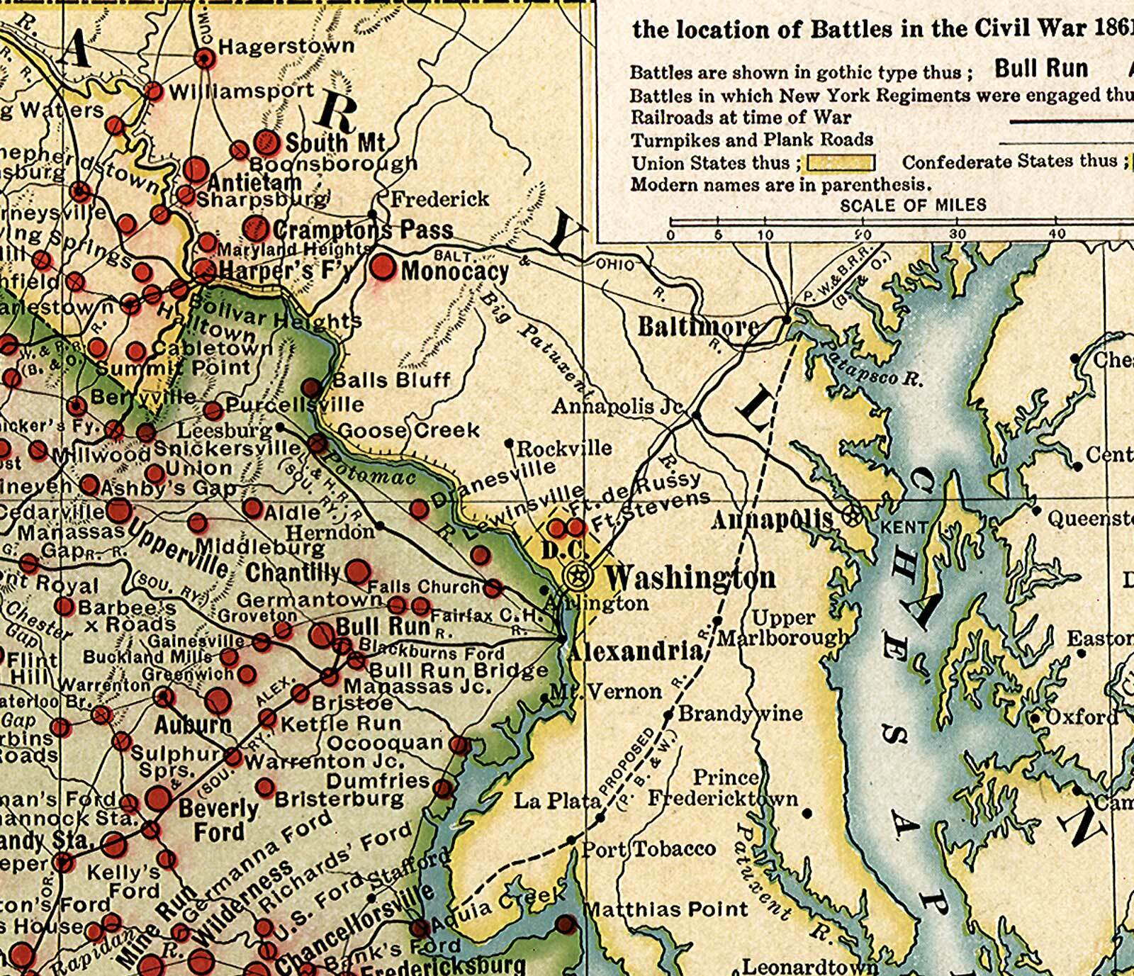
Map of Virginia and neighboring states showing the location of battles in the Civil War 1861-1865. This is a Reproduction of the Original Map This Map Comes in 2 Sizes: 11"x16" and 16"x24" We have more War Maps, you can find them in Our StoreWe also have a big selection of War Poster in Our StoreREMEMBER, the smaller the map size the harder it is to read the text.All Our Maps and Posters Are Made in the USA Map of eastern Virginia and parts of North Carolina, Maryland, West Virginia, and Pennsylvania, showing "battles in which New York regiments were engaged," "railroads at time of war," and "turnpikes and plank roads." Union states are colored yellow, and Confederate states are green. This map comes with a white border around the image --------------------------- -How are the maps shipped? They are rolled and placed into a rigid tube or box. -Is this available in a larger/smaller size. Yes. For smaller or larger sizes, email us.
Specifications
| Return Shipping Will Be Paid By | Seller |
| All Returns Accepted | Returns Accepted |
| Item Must Be Returned Within | 30 Days |
| Artist | Northrup, William P. |
| Character | Civil War |
| Country/Region Of Manufacture | United States |
| Department | Teens |
| Style | Vintage/Retro |
| Material | Paper |
| Theme | Military & Weaponry |
| Original/Reproduction | Reproduction |
| Type | Poster |
| Features | Unframed |
| Color | Multicolor |
| MPN | Does Not Apply |
| Subject | Civil War |
| Character Family | Civil War |
| Room | Home Office/Study |
| Brand | Unbranded |
| Production Style | Printed |
| Origin | United States |
| Item Height | 2 variations |
| Item Length | 2 variations |
| Item Width | 2 variations |
| Unit Type | Unit |
Map of Virginia and neighboring states showing the location of battles in the Civil War 1861-1865. This is a Reproduction of the Original Map This Map Comes in 2 Sizes: 11"x16" and 16"x24" We have more War Maps, you can find them in Our StoreWe also have a big selection of War Poster in Our StoreREMEMBER, the smaller the map size the harder it is to read the text.All Our Maps and Posters Are Made in the USA Map of eastern Virginia and parts of North Carolina, Maryland, West Virginia, and Pennsylvania, showing "battles in which New York regiments were engaged," "railroads at time of war," and "turnpikes and plank roads." Union states are colored yellow, and Confederate states are green. This map comes with a white border around the image --------------------------- -How are the maps shipped? They are rolled and placed into a rigid tube or box. -Is this available in a larger/smaller size. Yes. For smaller or larger sizes, email us.
Related Items